

6/12/12: We have written about the potential for the new dirigible (M1400) and its innovative sensor integration capabilities on board (Blue Devil 2).
But several capabilities of this program leap off of the page.
If the program was measured in a realistic manner, for example, ISR delivery equivalencies, this would be a priority program. To keep 6,000 pounds of ISR equipment on station for 78 hours it would take 39 current fixed wing UAVs or 1 M1400. It is hard to miss this point.
But also significant is the cost of the footprint. It is not just the question of 39 or whatever fixed wing UAVs.
It is about the SIZE of the footprint and the COST of the manpower for a deployment….

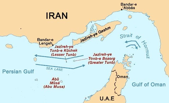
Imagine there was a threat in the Strait of Hormuz. Hard to do that I am sure.
If the Saudis or the UAE had some of these systems up, we could not only share the systems on board, but we could mix or match what would be there and determine JOINTLY how we would use and understand the data.
Confidence is rooted in part on having shared data BUILT in that allies can work from collectively
https://www.sldinfo.com/the-threat-of-airships/
We decided to pursue this subject to the next level and puzzle over the problem for which such an ISR solution provided an answer.
The Strait of Hormuz is located in a key geographical transit area and choke point.
The Strait of Hormuz is a narrow, strategically important strait between the Gulf of Oman in the southeast and the Persian Gulf. On the north coast is Iran and on the south coast is the United Arab Emirates and Musandam, an exclave of Oman.
The strait at its narrowest is 21 nautical miles (39 km) wide.[1] It is the only sea passage to the open ocean for large areas of the petroleum-exporting Persian Gulf and is one of the world’s most strategically important choke points. Around 20% of the world’s oil, which is about 35% of seaborne traded oil, passes through the strait.
http://en.wikipedia.org/wiki/Strait_of_Hormuz
We asked Lt. General (Retired) Deptula, former deputy chief of staff for intelligence, surveillance and reconnaissance (till October 2010) to provide us with an answer and a perspective. He was the principle attack planner for the 1991 Desert Storm air campaign and the director of the Combined Air Operations Center for Operation Enduring Freedom in 2001. He is a key player in the company building the dirigible and putting the innovative ISR solution set together.
SLD: What is the problem in the Strait of Hormuz for which your platform is a solution? In other words, what are we trying to solve by having a dirigible with this kind of capability airborne?
Deptula: Before we go directly to a particular material solution, what are the desired characteristics in watching that particular region, the Strait of Hormuz?
The first one that comes to mind is persistence.
You would like to have a capability that provides you with long dwell times to observe the comings and goings in the Strait of Hormuz as well as the approaches, incoming and outgoing. You would like to be able to observe activity that’s ongoing in Iran whether that be immediately along the coast or as far as inward as an airborne observation platform would allow one to view.
Persistence is certainly a characteristic that we’d like to capitalize on.
The second one is the variety of sensors that may be available or that are available in a variety of different modalities.
In other words, not just signals intelligence, not just imagery intelligence, not just measurement intelligence, not just radar, but the variety of different sensors that could be carried.
This would allow for continuous observation both in the Straits of Hormuz as well as on the landmass of Iran and along the coast.
And this could be accomplished all weather day or night.
And then finally, the other piece would be the potential of tipping and queuing of these different sensors to achieve a degree of multi-int integration that legacy ISR aircraft and spacecraft simply not been able to do.
These attributes for an ISR capability are definitional of what you would like to have to provide for support to the U.S. and its allies in the region. So for this very, very critical region, one could provide a solution via a highly persistent airborne vehicle with a modular capability and the payload to carry a variety of different intelligent sensors.
The system also is built around having an onboard processing capability to be able to do rapid tipping and queuing and then off boarding that information to a variety of different users, either there on scene or elsewhere around the world.
(For a description of multi-int integration or fusion see
http://geospatialtoday.com/gst/index.php?option=com_content&view=article&id=2504).
SLD: And in an area like the Strait which is a busy place, effective ISR always a challenge.
You have a lot of small boats, a lot of commercial shipping. So in fact, the complexity of tracking is very, very significant. To understand the tracks, to understand what are real threats, what are just normal commerce, so to speak, already requires a significant capability and by having that capability onboard, with the onboard processing, one is able to teach the machines to discriminate amongst the tracks, and this is certainly a part of the persistence competence you’d like to have.
It’s not just persistence; it’s kind of a airborne competence. Does that make sense?
Deptula: It does. In other words, you want to have an unblinking eye that can watch and as well as an unobstructed ear that can listen and then combine that information in a way that human senses do.
And that’s what a long duration airborne system with a variety of different sensors can provide, and that’s exactly what the M1400 does.
It is a traditionally designed dirigible or air ship with a payload compartment that is modular by design that can carry up to 10 separate sensors that can be switched out if the user wants to change among different kinds of sensors.
And located in or near the Straits of Hormuz, it could stay airborne from between five to seven days and provide signals intelligence coverage into Iran.
It could provide high definition video anywhere along the coast as well as continuous wide area airborne surveillance, immediately over the Strait of Hormuz to identify, track, and watch all the shipping in the area.
And it can do all of this at a fraction of the cost of traditional systems because you’re using a wide number or a number of different modes of sensors simultaneously and you’re using them to cross queue one another and achieve true multi-int capability.
SLD: And because of the complexity of what you’re looking at, you have a learning process to determine the proper mix and match of sensors would be better for what we’re determining are the most significant threats we have to deal with over time or in a specific moment in time.
Deptula: There are airborne systems that carry a variety of different imagers – infrared, electro-optic, and signals intelligence.
However, the processing exploitation and dissemination of the data collected from those different sensors is generally still accomplished in stovepipes, in ground stations and by analysts and organizations associated specifically for one type of ISR.
What an open architecture modular integrated system like the M1400 is designed to do is to integrate and leverage one sensor suite with another.
And the other value of the modularity of this process is if there were sensors that a particular user might want to try out, hyperspectral imaging for example, it could be done, as you mentioned, by switching it out in a matter of hours as opposed to weeks or months.
SLD: Allies are obviously a crucial part of this airspace, the UAE, Saudi Arabia, etc. The dirigible with the flexible ISR systems and architecture you described gives one the opportunity with the kind of space that you’ve got on this dirigible to allow you to mix and match systems or sensors.
And this would facilitate the kind of sharing that you’re going to need to come up with an allied solution set as well.
Is that a fair statement?
Deptula: That’s correct. Again, the combination of modularity, persistence, and payload size and amount gives allies an enormous degree of flexibility to capitalize on this platform.
And depending upon what sensor is being used, information can be sent directly to the user real time without any delay.
In this particular region, there’s no such thing as operating unilaterally.
We operate with partners and members of coalitions to accomplish our objectives and the flexibility inherent in this platform is just another reason for its being embraced and put to good use.